
THE REGION
Qalamoun: a region rebuilding
A highland region linked by towns, roads, water systems and a shared environmental future.
PLACE
A connected region
The Qalamoun region extends through the highlands north of Damascus and includes Qara, Deir Atiyeh, An-Nabk, Yabroud and surrounding towns and villages. Its communities are linked by the Damascus–Homs corridor, by routes towards Lebanon and by a landscape of limestone ridges, orchards, cultivated land and open steppe.
Water scarcity, long transport distances and the proximity of neighbouring towns shape everyday services. Waste, water, wastewater, land protection and municipal equipment may be managed locally, but many of the underlying challenges cross administrative boundaries.
This makes cooperation at regional level a practical necessity rather than an abstract institutional idea.
GEOGRAPHY
The towns of the corridor and the villages around them
Qalamoun is a highland region of limestone ridges rising west of the Damascus–Homs corridor and falling east towards open steppe. Orchards, vineyards and cultivated plots follow the water that the slopes and springs allow; beyond them the ground turns dry and stony. The main road runs north to south through the region, and mountain routes lead west towards Lebanon.
The region's main towns sit along or just off that corridor, within short distances of one another. Each functions as a local centre for administration, markets, schooling and municipal services, and each is surrounded by smaller settlements that depend on it.
- Qara
- The northernmost of the main towns, on the corridor towards Homs, where the highlands begin to open into the eastern steppe. Its position on the road makes it the first regional centre reached from the north.
- Deir Atiyeh
- South of Qara and close to the road, set against the ridges with orchard land on its approaches. It serves as a local service centre for the settlements on the slopes around it.
- An-Nabk
- The largest of the corridor towns, spread across the plain beside the road at the centre of the region. Traffic, trade and service journeys concentrate here, which also concentrates pressure on municipal services.
- Yabroud
- West of the corridor and higher into the mountains, reached by side roads through cultivated valleys. Its setting means longer service journeys and steeper terrain than the towns on the plain.
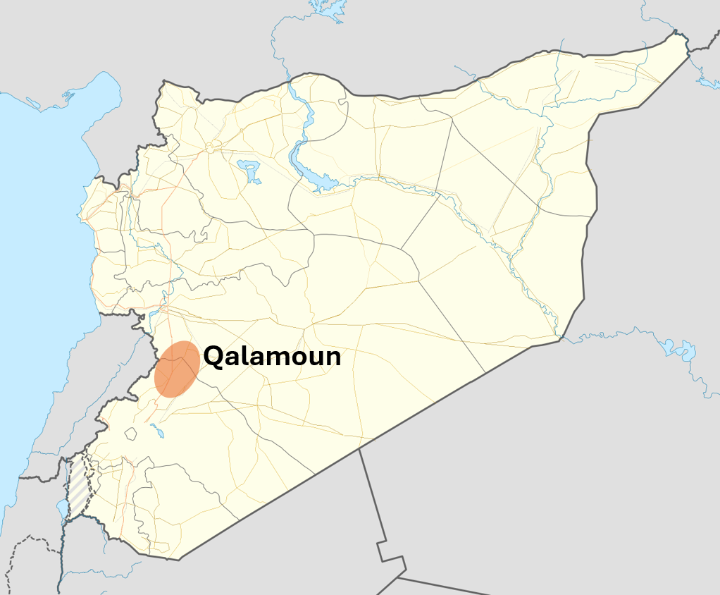

Around these four towns lie a number of smaller villages and hamlets, on the approaches to the corridor, along the side valleys and among the orchard terraces. They are not named individually here. Their populations are smaller and more dispersed, and they rely on the nearby towns for equipment, waste collection, water infrastructure and technical staff.
This pattern — four service centres, a shared road and a wide scatter of dependent settlements — is the practical reason the Foundation works at regional rather than single-town scale.
CONFLICT
A strategic corridor during the war
Qalamoun’s position along the principal route between Damascus and Homs, and beside mountain routes leading towards Lebanon, gave the region strategic importance during the conflict. Several towns experienced fighting, shelling, population movement and prolonged interruption to transport, commerce and public services, particularly during the military campaigns of 2013 and 2014.
This history should not define Qalamoun’s future. It does, however, explain why buildings, service networks, municipal equipment, local economies and household security remain under pressure long after the most intense fighting ended.

HUMAN IMPACT
Displacement and loss
International sources document particular episodes rather than a complete regional account. UNHCR estimated that approximately 18,000 Syrians crossed into Lebanon through Arsal between 15 and 22 November 2013. Refugees reported fleeing shelling in Qara, Al-Sahel, Deir Atiyeh and An-Nabk.
A United Nations communication issued in January 2014 reported that intense fighting had restricted humanitarian access in Qalamoun and that World Food Programme rations had been dispatched in December 2013 to address food shortages affecting an estimated 75,000 people in Deir Atiyeh and An-Nabk.
Qalamoun’s experience formed part of a much wider national tragedy. The Office of the United Nations High Commissioner for Human Rights estimated that 306,887 civilians were killed as a direct result of conflict-related operations in Syria between 1 March 2011 and 31 March 2021. At the end of 2025, UNHCR reported that 4.9 million Syrians remained refugees outside their country.
18,000
Qalamoun
documented rapid movement from Qalamoun into Lebanon, November 2013.
UNHCR, 22 November 2013
75,000
Deir Atiyeh and An-Nabk
estimated people affected by food shortages in Deir Atiyeh and An-Nabk, 2013.
United Nations, 31 January 2014
306,887
Syria
estimated civilian deaths across Syria, March 2011 to March 2021.
OHCHR, 28 June 2022
4.9 million
Syria
Syrian refugees at the end of 2025.
UNHCR, 11 June 2026
ESSENTIAL SERVICES
The damage extends beyond buildings
The visible destruction of housing and public buildings is only one part of the conflict’s legacy. Water networks, wastewater systems, waste collection, roads, electricity, municipal vehicles, workshops and public spaces were also damaged or weakened by prolonged disruption, economic contraction and inadequate investment.
When waste is not collected consistently, it accumulates at settlement edges, along roads and in uncontrolled dumping areas. Open burning releases smoke into surrounding neighbourhoods. Poorly protected disposal sites place land and groundwater at risk. Damaged water and sewer networks increase leakage, service interruptions and public-health pressure. Ageing municipal equipment makes even routine work difficult and costly.
These are not secondary concerns. They influence disease prevention, household safety, the condition of neighbourhoods, agricultural land and whether returning families can rebuild ordinary life.

RECOVERY
Recovery begins with systems that function
The World Bank estimated the cost of reconstructing Syria’s damaged physical assets at US$216 billion. It identified infrastructure as the largest category of direct physical damage and Rif Dimashq as one of the governorates most severely affected.
In February 2026, UNICEF reported that 14.4 million people across Syria required urgent water, sanitation and hygiene assistance. The scale is national, but the practical work takes place locally: repairing a network, restoring a pump, maintaining a vehicle, organising a collection route, preventing open dumping and protecting a water source.
Reliable services create the conditions for wider recovery. They protect health, support schools and businesses, reduce pressure on households and make it possible for communities to plan beyond immediate survival.

WHY THE FOUNDATION
A focused regional contribution
Syria’s public institutions are rebuilding administration and essential services while facing needs across the entire country. The Qalamoun Foundation for Development and Environment concentrates on the requirements of this region.
The Foundation develops practical initiatives around shared environmental and development priorities. It works to bring together local knowledge, Syrian technical expertise, public institutions, implementation capacity and potential sources of support.
The Foundation does not seek to replace public authorities. Its contribution is to maintain a sustained regional focus, prepare workable initiatives and support the cooperation required when environmental and infrastructure challenges extend beyond a single town.
Sources
- UNHCR, “Syrians fleeing fighting in Qalamoun stream into Lebanon’s Bekaa Valley”, 22 November 2013.
- United Nations Special Procedures communication SYR 3/2014, 31 January 2014.
- Office of the United Nations High Commissioner for Human Rights, civilian casualty estimate for Syria, 28 June 2022.
- World Bank, Syria Physical Damage and Reconstruction Assessment 2011–2024, 21 October 2025.
- UNICEF Syria, water and sanitation press release, 5 February 2026.
- UNHCR, Global Trends 2025, published 11 June 2026.